The Quays
The Quay, looking towards the New Bridge
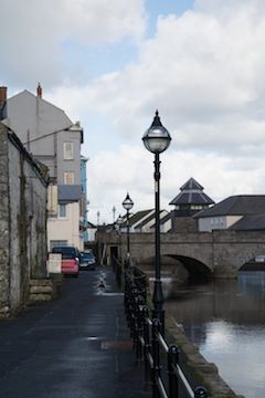
Haverfordwest is situated on the upper tidal limit of the river Cleddau. With its central position it had the advantage of attracting trade from all parts of the county and further. For centuries it was the most important port in Wales; a fact shown in the customs records throughout the Middle Ages. From here ships made for ports all over western Europe carrying wheat, barley and oats, or bringing in salt, wine, sugar and iron. There were several quays on this side of the river and you are currently walking along New Quay.
Quay Street. Running parallel with the path that you are currently on is Quay Street which was the street that led to the main quays. All trade into and out of the town came via Quay Street, formerly and appropriately called Ship Street. This was the street that was the nerve centre of the port. In it, and along it, were chandlers’ stores, pubs, brothels and warehouses, a few of which remain (that’s warehouses by the way).
A smaller example of these was a 15th century, extremely strong, storeroom with living accommodation above for a caretaker; which has become known as, The Merchant’s House. This building was dismantled in the 1980s and thirty years later re-erected by the same masons in St Fagan’s Museum on the outskirts of Cardiff.
But more than just trade came up this street and in late 1651 the bubonic plague arrived by ship, probably from Dublin. For six months the town of Haverfordwest battled once again against the horrors of plague, with noble efforts made to contain it by closing the town and opening ‘Pest Houses’.
The Old Quay. Iron rings embedded into the stonework along the top to which ships were secured can still be seen on the Old Quay.
Also along this quay can still be seen surviving 19th century warehouses. Besides their usage for trade goods, rooms within them were at various times used by early Quakers and Moravians for their meetings.
The Bristol Trader is an extremely old pub named for one of the most important links that the town had trade with.
On the roadside of the last warehouse, high on the wall, is a wooden plaque placed there in the very early twentieth century by another religious group still faintly showing the times of meetings.
Into the steep bank opposite are the last of the properties that once ran along both sides of the road and which were once small manufacturing businesses that catered for the shipping. These two still carry the names of Factory Cottage and Tannery Cottage.
With the arrival of the railway in December 1853 the importance of the river and the quays fell markedly and the once vibrant small industry structures became slums that were cleared and demolished in the 1930s.
Continue to the bottom of the steep hill (Union Hill) and turn left into the narrow entrance passageway that brings you into...
Base map from openstreetmap.org
What month did the steamship 'Frolic' founder with the loss of 80 lives? Tap to reveal answer.